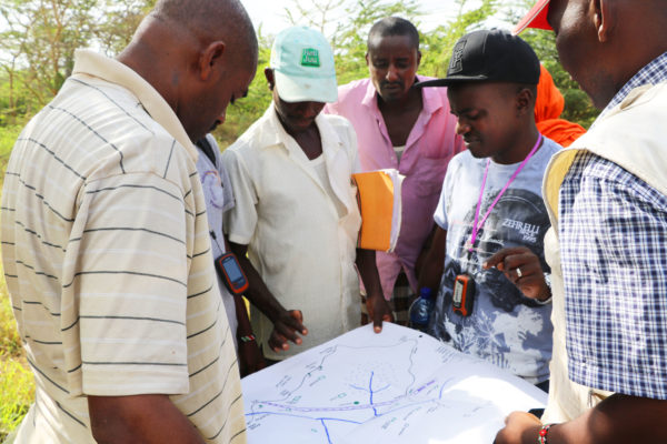
This blog post explains how Namati and the Kenya Land Alliance piloted a participatory community mapping process with two communities in Tana River, Kenya. Namati and KLA used handheld GPS devices to record boundary and feature locations and then used that data in QGIS software to create maps that were validated by the communities.
Or, access this resource as a guest by sharing your email below.
Last updated January 30, 2013.
Welcome to the grassrootsjusticenetwork.org website (the “Site”), operated by Namati, Inc., a Delaware corporation (“Namati”, “we”, “us” or “our”). Your use of the Site or use of any of the services offered on or via the Site (collectively, the “Services”) is subject to these terms of use (the “Terms”). We may modify the Terms at any time without notice to you by posting revised versions of the Terms on our Site. Your use of the Site and any Services constitutes your binding acceptance of the Terms and Namati’s Privacy Policy, including any modifications that we make. If you do not agree to the Terms, do not use this website.
You must register in order to upload Tools to the Tools Database, obtain full access to Tools, participate in discussion forums and fully utilize any networking functions on the Site. To register, you must be 18 years or older, have the requisite power and authority to enter into the Terms, truthfully and accurately provide all required information, including a legitimate email address, and obtain a unique username and password.
You are responsible for maintaining the confidentiality of your account and password, and you agree to accept responsibility for all activities that occur under your account or password. Furthermore, you are strongly advised to maintain and to protect your privacy by choosing carefully what personally identifiable information you provide on the Site.
Your use of the Site is at your own risk, including the risk that you might be exposed to Content that you find offensive or that is inaccurate, objectionable or otherwise inappropriate. Your use of the Site constitutes your acknowledgment that you bear all risks associated with using such Content.
Our Site includes a combination of content that we, our users and other third parties create (collectively, the “Content”). All of the Content available through the Site including, but not limited to, written content, photographs, graphics, images, illustrations, marks, logos, sound or video clips, and animations, is trademarked or copyright protected. Content posted to the Tools Database at grassrootsjusticenetwork.org/tools (such content, the “Tools”) is intended to be used as part of a platform provided for practitioners to share experiences and resources, including, but not limited to, research, training materials, monitoring and evaluation tools, case management systems and advocacy strategies. You may use a Tool to assist in performing issue advocacy consistent with the mission of Namati as published at https://grassrootsjusticenetwork.org/about/our-mission (the “Mission”), provided that your use of a Tool must in no way violate any law of the jurisdiction in which such Tool is used. Except as permitted herein, you may not use, store, display, modify, reproduce, publish, transmit, participate in the transfer or sale of, create derivative works of, distribute, publicly perform, publicly display or in any way exploit any of the materials or content on the Site in whole or in part.
You are solely responsible for all materials, whether publicly posted or privately transmitted, that you upload, post, email, transmit or otherwise make available on the Site (“Your Content”). You represent that you own or have the necessary permissions to use and authorize the use of Your Content as described herein. You may not imply that Your Content is in any way sponsored or endorsed by Namati. You assume all risks associated with posting and sharing Your Content, including anyone’s reliance on its quality, accuracy or reliability. Prohibited content includes, but is not limited to, and you represent that you will not post Content that is:
We may from time to time, examine the Content on the Site or at the point of upload. We have the right, but not the obligation, to remove or decline to post any Content that may, in our sole discretion, violate these Terms or that is otherwise objectionable to us. We are not responsible for the loss, deletion, failure to store, misdelivery or untimely delivery of any Content submitted to or transmitted through the Site. We have no obligation to retain or provide you with copies of Your Content, nor do we guarantee any confidentiality with respect to Your Content. You may not post, or attempt to post, Content that interferes with our normal operations or with the use and enjoyment of another user. You may access the Site and the Content only through the interfaces provided by us. You agree to use the Site and the Services only for their intended lawful purpose and in accordance with applicable laws.
You certify that either (i) you own all intellectual property rights in Your Content, or (ii) in posting or transmitting Your Content, you are acting with the permission of the owners of such Content to both (a) post such Content and to (b) grant any further licenses to such Content or permissions to use such Content as described herein. When you post or transmit Your Content on or through the Site you grant Namati a perpetual, worldwide, irrevocable, royalty-free, nonexclusive and sublicensable license (the “License”) to use, reproduce, create derivative works of, distribute, publicly perform, publicly display, transfer, transmit, distribute and publish Your Content and subsequent versions of Your Content for the purposes of (i) displaying Your Content on the Site, (ii) distributing Your Content, either electronically or via other media, to users seeking to download or otherwise acquire it, (iii) storing Your Content in a remote database accessible by end users, and/or (iv) providing Services through and outside of the Site, including, but not limited to, implementing interventions expanding legal empowerment, offering technical assistance to development organizations, governments and civil society actors and hosting workshops for members. The License shall apply to the distribution and the storage of Your Content in any form, medium or technology now known or later developed.
When you post or transmit Your Content on or through the Site you also irrevocably grant the users of the Site the right to access and use Your Content in connection with the use of the Site.
If we request registration information from you, you will provide us with true, accurate, current and complete information. If you are registering on behalf of an organization, you represent that you have the necessary permissions and/or authority from that organization to (i) register the organization as a member of the Site and (ii) act on behalf of and in the name of that organization in any interactions with the Site, including, but not limited to, posting of Content to the Tools Database and discussion forums. You will promptly update your registration or that of your organization to keep it accurate, current and complete. If we issue you a password, you may not reveal it to anyone else and you may not use another person’s password. You agree to immediately notify us of any unauthorized use of your passwords or accounts or any other breach of security. We will not be responsible for any loss or damage that may result if you fail to comply with these requirements. The technology and the software underlying the Site and the Services is the property of Namati and our contractors. You agree not to copy, modify, rent, lease, loan, sell, assign, distribute or reverse engineer any of the technology or software underlying the Site or the Services. You agree not to modify the software underlying the Site in any manner or in any form or to use modified versions of such software, including, without limitation, for the purpose of obtaining unauthorized access to the Site.
Without limiting the foregoing, you agree that you will not use our Site to take any of the following actions:
If you choose a username that, in our sole discretion, is obscene, indecent or abusive, we reserve the right, without prior notice to you, to automatically change your username, delete your posts from the Site, deny you access to the Site or employ any combination of these options. Unauthorized access to the Site is a breach of these Terms and a violation of the law. You agree not to use any automated means, including, without limitation, agents, robots, scripts or spiders, to access, monitor or copy any part of the Site, except those automated means that we have approved in advance and in writing. Use of the Site is subject to existing laws and legal process. Nothing contained in these Terms shall limit our right to comply with governmental, court and law-enforcement requests or requirements relating to your use of the Site.
We have the right, but not the obligation, to take any of the following actions, in our sole discretion, at any time and for any reason without giving you any prior notice:
You agree that we will not be liable to you or any third party for taking any of these actions. You understand and agree that our Services may include communications such as service announcements and administrative messages from us and that these communications are considered part of the Services. We may also contact you via email to notify you about special events available to Site registrants. By becoming a Site registrant you consent to the receipt of these communications. You will be able to opt out of receiving these messages.
The Site is intended to provide general information about Namati, its mission of legal empowerment and programs and research which we support and to provide practitioners with an online network for the sharing of resources and experiences, including research, training materials, monitoring and evaluation tools, case management systems and advocacy strategies. The Site is not engaged in the provision of professional advice or information. Content posted on the Site should be considered as opinion only and should not be taken as a substitute for, without limitation, legal or other professional advice from a qualified service provider. We make no representations or warranties concerning any action taken by any person in reliance on the information provided through the Site. We will not be liable for any damages that may result, including but not limited to direct, indirect, consequential, special or other damages or economic loss, illness, injury or death.
The Site provides access and contains links to third-party Internet sites and services. Inclusion of these links and services on the Site does not constitute our endorsement of the materials on those third-party sites and does not signify any association with the owners or operators of those third-party sites and services. Your use of such third-party sites and services is subject to the terms and conditions set by the third-party site or service in question. We have no control over these third parties, and we are not responsible for their activities. You may receive email communications from third parties if you utilize a third-party service provided through the site. We do not sell, resell or license any of the products or the services related to any third-party sites, and we disclaim any responsibility for or liability related to them. Your correspondence or related activities with third parties, including payment transactions and goods-delivery transactions, remain solely between you and that third party. You agree that we will not be responsible for or liable for any loss or damage of any sort incurred as the result of any of your transactions with third parties. Any questions, complaints, or claims related to any third-party product or service should be directed to the appropriate vendor.
You represent that you have read, have understood and accept our Privacy Policy (the “Privacy Policy”). Note that we may disclose information about you to third parties if you have requested or authorized the disclosure or if we have a good faith belief that such disclosure is reasonably necessary to (i) take action regarding suspected illegal activities, (ii) enforce or apply our Terms and Privacy Policy, (iii) comply with legal process or other government inquiry, such as a search warrant, subpoena, statute, judicial proceeding or other legal process served on us or (iv) protect our rights, reputation and property, or that of our users, affiliates or the public. Please click here to see our full Privacy Policy.
The Site and Services are offered from the United States. We make no representations or warranties that the Site or Services are appropriate or available for use in countries outside of the United States. Visitors who choose to access the Site and Services from outside of the United States do so at their own initiative and are responsible for compliance with any and all local laws and regulations that may apply to such access. If you use the Site outside of the United States, you consent to having your personal data transferred to and processed in the United States. Access to the Site and the services is prohibited where such access or use violates applicable laws or regulations.
We disclaim any and all responsibility and liability for (i) the deletion, the failure to store, the misdelivery or the untimely delivery of any information or material; (ii) any harm resulting from downloading or accessing any information or material on the Internet using search results from our Site; and (iii) any service outages that are caused by our maintenance on the servers or the technology that underlies the Site, failures of our Service providers (including telecommunications, hosting and power providers), computer viruses, natural disasters or other destruction or damage of our facilities, acts of nature, war, civil disturbance or any other cause beyond our reasonable control. WE DO NOT WARRANT THAT THE SITE WILL BE UNINTERRUPTED OR ERROR FREE. IN ADDITION, WE DO NOT MAKE ANY REPRESENTATION OR WARRANTY AS TO THE CONTENT ON THE SITE. THE SITE AND THE CONTENT ARE DISTRIBUTED ON AN “AS IS, AS AVAILABLE” BASIS. ANY MATERIAL THAT YOU DOWNLOAD OR OTHERWISE OBTAIN THROUGH THE SITE IS DONE AT YOUR OWN DISCRETION AND RISK, AND YOU WILL BE SOLELY RESPONSIBLE FOR ANY POTENTIAL DAMAGES TO YOUR COMPUTER SYSTEM OR LOSS OF DATA THAT RESULTS FROM YOUR DOWNLOAD OF ANY SUCH MATERIAL. WE MAKE NO WARRANTIES THAT (i) THE SITE WILL MEET YOUR REQUIREMENTS, (ii) THE SITE WILL BE UNINTERRUPTED, TIMELY, SECURE OR ERROR FREE, (iii) THE RESULTS THAT MAY BE OBTAINED FROM THE USE OF THE SITE WILL BE ACCURATE OR RELIABLE, (iv) THE QUALITY OF ANY PRODUCTS, SERVICES, INFORMATION OR OTHER MATERIAL THAT YOU OBTAIN THROUGH THE SITE WILL MEET YOUR EXPECTATIONS, OR (v) ANY ERRORS WILL BE CORRECTED. WE MAKE NO REPRESENTATIONS OR WARRANTIES OF ANY KIND, EITHER EXPRESS OR IMPLIED, INCLUDING, WITHOUT LIMITATION, WARRANTIES OF TITLE OR IMPLIED WARRANTIES OF MERCHANTABILITY, FITNESS FOR A PARTICULAR PURPOSE OR NON-INFRINGEMENT WITH RESPECT TO THE SITE, ANY CONTENT OR ANY OF OUR SERVICES, TOOLS, PRODUCTS OR PROPERTIES. YOU EXPRESSLY AGREE THAT YOU WILL ASSUME THE ENTIRE RISK AS TO THE QUALITY AND THE PERFORMANCE OF THE SITE AND THE ACCURACY OR COMPLETENESS OF ITS CONTENT. IN ADDITION, WE DO NOT GUARANTEE THE ACCURACY, INTEGRITY OR QUALITY OF THE CONTENT ON THE SITE, AND YOU MAY NOT RELY ON ANY OF THIS CONTENT. WITHOUT LIMITATION, WE ARE NOT RESPONSIBLE FOR POSTINGS BY USERS IN ANY INTERACTIVE SECTIONS OF THE SITE, INCLUDING, BUT NOT LIMITED TO, THE TOOLS DATABASE. WE SHALL NOT BE LIABLE FOR ANY DIRECT, INDIRECT, INCIDENTAL, SPECIAL OR CONSEQUENTIAL DAMAGES ARISING OUT OF THE USE OF OR INABILITY TO USE THE SITE, EVEN IF WE HAVE BEEN ADVISED OF THE POSSIBILITY OF SUCH DAMAGES. SOME STATES DO NOT ALLOW EXCLUSION OF IMPLIED WARRANTIES OR LIMITATION OF LIABILITY FOR INCIDENTAL OR CONSEQUENTIAL DAMAGES, SO THE ABOVE LIMITATIONS OR EXCLUSIONS MAY NOT APPLY TO YOU. IN SUCH STATES, OUR LIABILITY SHALL BE LIMITED TO THE FULLEST EXTENT PERMITTED BY LAW.
By utilizing the Site, you agree to indemnify, defend and hold Namati and all of its officers, directors, employees, representatives, Advisory Council members, Network Guidance Committee members, agents, information providers and licensors (collectively, the “Namati Parties”) harmless from and against any and all liability, losses, costs and expenses (including attorneys’ fees) incurred by any Namati Party in connection with any claim, including, but not limited to, claims for defamation, violation of rights of publicity and/or privacy, copyright infringement or trademark infringement arising out of:
You also agree to take sole responsibility for any royalties, fees or other monies owed to any person by reason of any Content you post or transmit through the Site or the Services we provide. We reserve the right, at our own expense, to assume the exclusive defense and control of any matter for which you are required to indemnify us, and you agree to cooperate with our defense of these claims.
By visiting or using the Site, you agree that the laws of the State of New York, without regard to principles of conflicts of law, will govern our Privacy Policy and these Terms and any dispute of any sort that might arise between you and Namati. You agree that any action at law or in equity that arises out of or relates to any use of the Site will be filed only in the state or federal courts located in New York County, and you hereby consent and submit to the personal jurisdiction of such courts for the purposes of litigating any such action.
Materials may be made available through the Site by third parties who are not under our control. Namati respects the copyright interests of others and, as such, requires our users to comply with all Terms regarding copyrights. It is our policy to terminate user accounts for failure to comply with our copyright policy. If you believe that any Content shown on or transmitted through the Site violates these Terms or your copyright please report the violation. In the case of a copyright violation please provide a written notice with a physical or electronic signature and the following information:
All notices should be sent to our designated agent as follows:
It is often difficult to determine if your intellectual property rights have been violated. We may request additional information before we remove allegedly infringing material.
We may be required by state or federal law to notify you of certain events. You hereby acknowledge and consent that such notices will be effective upon our posting them on the Site, our delivering them to you through email or your otherwise becoming aware of such notices through other means. If you do not provide us with accurate information, we cannot be held liable if we fail to notify you. Our failure to exercise or enforce any right or provision of these Terms shall not constitute a waiver of such right or provision. You agree that regardless of any statute or law to the contrary, any claim or cause of action arising out of or related to use of the Site or these Terms must be filed within one (1) month after such claim or cause of action arose or it will be forever barred. These Terms, including the Privacy Policy, constitute the entire agreement between you and Namati and govern your use of the Site, superseding any prior agreements that you may have with us. If any part of these Terms is determined to be invalid or unenforceable pursuant to applicable law, then the invalid or unenforceable provision will be deemed superseded by a valid, enforceable provision that most closely matches the intent of the original provision and the remainder of the Terms shall continue in full force and effect.
Last updated: April 26, 2024
Welcome to the grassrootsjusticenetwork.org website (the “Site”) and the Grassroots Justice Network Forum (the “Forum”) operated by Namati, Inc., a Delaware corporation (“Namati”, “we”, “us” or “our”). We share your concern about the protection of your personal information online.
This privacy policy (“Policy”) describes how we maintain the privacy of the personal information we collect online in connection with the Site. Our processing of personal data of people who are in the EEA is governed by EU General Data Protection Regulation 2016/679 (EU GDPR) and for those who are in the United Kingdom by the UK version of the EU GDPR (UK GDPR) and by the UK Data Protection Act 2018. Namati is the data controller for this website and for our contact information , see the section in our general Privacy Statement headed “Your Rights under the Policy”.
This Policy describes our privacy practices and sets out your obligations and ours with respect to your use of the Site and the Forum. This Policy applies only to the Site and the Forum and does not necessarily apply to our offline collection of information.
By using the Site and/or Forum, you agree to abide by the terms of this Policy and the terms of use (the “Terms”) and you consent to our using any information that you provide to us or that we collect, in accordance with the terms of use and the terms and conditions of this policy. If you do not agree to this policy and the terms, do not use the site.
Namati may collect and retain two types of information about Site visitors: (i) personal information that individual visitors voluntarily provide when interacting on the Site or on certain other occasions (such as via forms or in emails); and (ii) tracking data, which is data that is automatically collected from every Site visitor as they use and browse the site.
We may, from time to time, store and archive the information you submit to or through the Site. The information that we gather may include your name, title and address, telephone number, email address, credit card number or other elements of personal information. In addition, if you contact us, we may keep a record of your correspondence, including any information contained therein.
You may decline to provide any personal information, but please realize that you thereby may be unable to register or to participate in activities or services offered on the Site and/or Forum.
In addition to the information you submit to or through the Site, we also may collect and store data from and about you gathered in the course of your use of the Site. We call this “tracking data.”
Such tracking data may include, but is not limited to, information regarding the number and frequency of visits to the Site, the websites that you access before and after you visit the Site, the software and operating system used to access the Site and your IP address and Internet service provider.
The information that you provide to us and that we may collect in the future is used for our legitimate interests and the purpose for which you provided it only, subject to the terms of this Policy and the Terms.
Our use of your Information involves various forms of communication with you, including:
We will not disclose any personal information to third parties, except:
Information provided to third parties is limited to the information needed to perform their functions. We seek to limit third-party use of information and our service providers have entered into contracts with us that restrict what they can do with your personal information. If you would like specific information about our service providers who have received your information, please contact us at privacy@namati.org and we will provide that information to you.
We retain the right to transfer or assign all information pursuant to a merger, purchase or other transaction relating to Namati or our assets.
The current list of third party service providers we use include:
| COOKIE NAME | PROVIDER | CATEGORY | DESCRIPTION |
|---|---|---|---|
| wp_lang | grassrootsjusticenetwork.org | necessary | |
| wordpress_test_cookie | grassrootsjusticenetwork.org | necessary | Cookie set by WordPress to check if the cookies are enabled on the browser to provide appropriate user experience to the users |
| _gat | grassrootsjusticenetwork.org | analytics | Used to monitor number of Google Analytics server requests when using Google Tag Manager |
| lidc | linkedin.com | advertisement | Used by the social networking service, LinkedIn, for tracking the use of embedded services. |
| __hssrc | grassrootsjusticenetwork.org | analytics | Used to determine if a session is a new session |
| li_sugr | linkedin.com | analytics | Used to make a probabilistic match of a user's identity outside the Designated Countries |
| UserMatchHistory | linkedin.com | advertisement | These cookies are set by LinkedIn for advertising purposes, including: tracking visitors so that more relevant ads can be presented, allowing users to use the 'Apply with LinkedIn' or the 'Sign-in with LinkedIn' functions, collecting information about how visitors use the site, etc. |
| YSC | youtube.com | functionality | Registers a unique ID to keep statistics of what videos from YouTube the user has seen. |
| _ga | grassrootsjusticenetwork.org | analytics | ID used to identify users |
| bcookie | linkedin.com | advertisement | Used by LinkedIn to track the use of embedded services. |
| _ga_W3R156NSLL | grassrootsjusticenetwork.org | analytics | Used to persist session state |
| IDE | doubleclick.net | advertisement | This cookie is used for targeting, analyzing and optimisation of ad campaigns in DoubleClick/Google Marketing Suite |
| __hs_do_not_track | grassrootsjusticenetwork.org | necessary | Prevents the tracking code from sending any information to HubSpot |
| __cf_bm | grassrootsjusticenetwork.org | necessary | Cloud flare's bot products identify and mitigate automated traffic to protect your site from bad bots. Cloudflare places the __cf_bm cookie on End User devices that access Customer sites that are protected by Bot Management or Bot Fight Mode. The __cf_bm cookie is necessary for the proper functioning of these bot solutions. |
| _gid | grassrootsjusticenetwork.org | analytics | ID used to identify users for 24 hours after last activity |
| hubspotutk | grassrootsjusticenetwork.org | analytics | Contains visitor's identity |
| __hstc | grassrootsjusticenetwork.org | analytics | Analytics tracking cookie |
| __cf_bm | vimeo.com | necessary | Cloud flare's bot products identify and mitigate automated traffic to protect your site from bad bots. Cloudflare places the __cf_bm cookie on End User devices that access Customer sites that are protected by Bot Management or Bot Fight Mode. The __cf_bm cookie is necessary for the proper functioning of these bot solutions. |
| _gcl_au | grassrootsjusticenetwork.org | advertisement | Used by Google AdSense for experimenting with advertisement efficiency across websites using their services. |
| bscookie | linkedin.com | advertisement | Used by LinkedIn to track the use of embedded services. |
| VISITOR_INFO1_LIVE | youtube.com | advertisement | Tries to estimate the users' bandwidth on pages with integrated YouTube videos. |
| AnalyticsSyncHistory | linkedin.com | functionality | Used to store information about the time a sync with the lms_analytics cookie took place for users in the Designated Countries |
| __hssc | grassrootsjusticenetwork.org | analytics | Analytics session cookie |
| vuid | vimeo.com | analytics | This first party cookie created by Vimeo is used to assign a Vimeo Analytics unique id. |
| __hs_cookie_cat_pref | grassrootsjusticenetwork.org | necessary | The HubSpot Cookie Banner's consent preferences cookie. |
| ar_debug | google-analytics.com | ||
| VISITOR_PRIVACY_METADATA | youtube.com | ||
| NID | google.com | necessary | This cookies is used to collect website statistics and track conversion rates and Google ad personalisation |
| cf_clearance | vimeo.com | ||
| __cf_bm | hsforms.com | necessary | Cloud flare's bot products identify and mitigate automated traffic to protect your site from bad bots. Cloudflare places the __cf_bm cookie on End User devices that access Customer sites that are protected by Bot Management or Bot Fight Mode. The __cf_bm cookie is necessary for the proper functioning of these bot solutions. |
| JSESSIONID | nr-data.net | functionality | JSESSIONID is a platform session cookie and is used by sites with JavaServer Pages (JSP). The cookie is used to maintain an anonymous user session by the server. |
| _cfuvid | vimeo.com | necessary | This cookie is used to apply rate limits to traffic. It allows the Cloudflare WAF to distinguish individual users who share the same IP address. |
Personal information you submit via your member account, other than information provided or content posted by you to public areas of the Site as described below, is deleted from Namati’s records following the deletion of your account. However, such information may continue to be retained by third-party service providers to which it has been disclosed for one of the reasons listed above. Any financial records will be kept in accordance with Namati’s data retention policy.
Your Information is stored on Digital Ocean servers in New York, USA. When you provide personal information to us, we request your consent to transfer that personal information to the USA. The USA does not have an adequacy decision from the European Commission, which means that the Commission has not determined that the laws of the USA provide adequate protection for personal information. Although the laws of the USA do not provide legal protection that is equivalent to the EU GDPR, we safeguard your personal information by treating it in accordance with this Policy. We take appropriate steps to protect your privacy and implement reasonable security measures to protect your personal information in storage. We use secure transmission methods to collect personal data through our website. We also enter into contracts with our data processors that require them to treat personal information in a manner that is consistent with this Policy.
We have put in place appropriate security measures to prevent your personal data from being accidentally lost, used or accessed in an unauthorized way, altered or disclosed. In addition, we limit access to your personal data to those employees, agents, contractors and other third parties who have a business need to know. They will only process your personal data on our instructions and they are subject to a duty of confidentiality.
We have put in place procedures to deal with any suspected personal data breach and will notify you and any applicable regulator of a breach where we are legally required to do so.
You should be aware that any information provided or content posted by you to public areas of the Site, including but not limited to interactions on the Site and information posted to the Member Directory (via your profile), the Resource Library, and the Forum, may be read, collected or used by other visitors of the Site, who may not need to log in as a member to view the information. Namati is not responsible for the third-party use of any information provided in such manner. By participating in the use of the Site’s interactive features, you consent to Namati’s use or disclosure of any content that you submit. For more information on posting content, please see our Terms.
The Forum uses data about your posts and other activity to make automated decisions about whether your posts are spam.
The Forum may also use data about your posts and activity to award you badges and calculate a trust level for your account. Your trust level may affect how you can participate in the Forum, such as whether you can upload images, as well as give you access to moderation and management powers in the Forum. Your trust level therefore reflects Forum administrators’ confidence in you, and their willingness to delegate community management functions, like moderation.
From time to time, we may email users of the Site information regarding important developments affecting Namati. We may also email users on occasion regarding the Site. Such emails may be sent to users of the Site if they have given their consent previously or if they have requested information from us or acquired goods or services from us in the past and have not opted out of receiving marketing communications. You can ask us to stop sending you marketing messages at any time by (i) logging into the website and checking or unchecking relevant boxes to adjust your marketing preferences; or (ii) by following the opt-out links on any marketing message sent to you; or (iii) by contacting us at any time.You may choose to unsubscribe from future emails by using the unsubscribe link included in all mass email correspondence from Namati.
If a user elects to use our referral service to inform a friend about the Site and Forum, we request the name and email address of the friend. Namati will automatically send the friend a one-time email inviting the friend to visit the Site. Namati stores this information for the sole purpose of sending this one-time email, and, while a third-party mail service provider may retain the information in its database, no additional emails will be sent by Namati without further action by the friend.
The Site and the Forum may contain links to websites owned and operated by other parties. We are not responsible for and have no control over the privacy policies of those sites. We encourage you to review the privacy policies and terms of use of those sites prior to providing them with any information.
Namati uses cookies. Cookies are small pieces of information that a website transfers to your computer’s hard drive for record-keeping purposes and may have unique identifiers and transmit information about you and how you use the Site. Such information may include your search preferences, your browser type and the date and time of use. If you choose, you can disable some (but not all) Cookies in your device or browser settings, but doing so may affect your ability to use the Site.
Namati does permit several non-advertising third parties to set third-party cookies in order to enhance Site functionality. These third parties may include, but are not limited to: Facebook, Google, and Vimeo. For more information on the cookies that these third parties set, users are encouraged to consult the privacy policies and terms of use of these third parties.
Namati is concerned about the privacy protection of children who access the Internet and this website is not intended for children and we do not knowingly collect data relating to children. Accordingly, the Site and Forum are not intended for use by anyone under the age of 16, and we do not knowingly collect information from anyone under 16 years of age without the consent of a parent or guardian.
We reserve the right to disclose any information to comply with any law, regulation, decree, judgment, order, subpoena or any other governmental order (“Order”) without any obligation to contest or verify the accuracy of such Order.
This Policy will be governed by and construed in accordance with the laws of the State of New York, without regard to any principles of conflicts of law. You agree that any action at law or in equity that arises out of or relates to any use of the Site may be filed:
The section titles in this Policy are for convenience only and have no legal or contractual effect. The Site, the Forum, and any third-party services they use, may be subject to additional terms and conditions regarding privacy and use of information. Your use of the Site and the Forum is subject to those terms and conditions, which are incorporated into this Policy by reference. In the event of an inconsistency between this Policy and any additional posted conditions, the provisions of the additional conditions shall control.
We may need to change the Policy from time to time in order to address new issues and to reflect changes on the Site or in the law. We reserve the right to revise or make any changes to the Policy, and your continued use of the Site subsequent to any changes to this Policy will mean that you agree to and accept such changes. You can tell if the Policy has been updated by checking the last revised date posted on the top of this page. Historic versions can be obtained by contacting us at privacy@namati.org
You can access, remove, update or correct your information in your Site profile (https://grassrootsjusticenetwork.org/connect/member/YOUR USERNAME HERE/?edit=1) and your Forum profile (https://connect.grassrootsjustice.network/u/YOUR USERNAME HERE/preferences/account).
You can also access, remove, update or correct your information, and raise any questions or concerns regarding the Site or the Policy, by emailing privacy@namati.org, or mailing:
Namati Data Protection Officer 1616 P Street NW, Suite 101 Washington, DC 20036, USA
It is important that the personal data we hold about you is accurate and current. Please keep us informed if your personal data changes during your relationship with us.
You have the right to:
Request access to your personal data (commonly known as a “data subject access request”). This enables you to receive a copy of the personal data we hold about you and to check that we are lawfully processing it.
Request correction of the personal data that we hold about you. This enables you to have any incomplete or inaccurate data we hold about you corrected, though we may need to verify the accuracy of the new data you provide to us.
Request erasure of your personal data. This enables you to ask us to delete or remove personal data where there is no good reason for us continuing to process it. You also have the right to ask us to delete or remove your personal data where you have successfully exercised your right to object to processing (see below), where we may have processed your information unlawfully or where we are required to erase your personal data to comply with local law. Note, however, that we may not always be able to comply with your request of erasure for specific legal reasons which will be notified to you, if applicable, at the time of your request.
Object to processing of your personal data where we are relying on a legitimate interest (or those of a third party) and there is something about your particular situation which makes you want to object to processing on this ground as you feel it has an impact on your fundamental rights and freedoms. You also have the right to object where we are processing your personal data for direct marketing purposes. In some cases, we may demonstrate that we have compelling legitimate grounds to process your information which override your rights and freedoms.
Request restriction of processing of your personal data. This enables you to ask us to suspend the processing of your personal data in the following scenarios:
Request the transfer of your personal data to you or to a third party. We will provide to you, or a third party you have chosen, your personal data in a structured, commonly used, machine-readable format. Note that this right only applies to automated information which you initially provided consent for us to use or where we used the information to perform a contract with you.
Withdraw consent at any time where we are relying on consent to process your personal data. However, this will not affect the lawfulness of any processing carried out before you withdraw your consent. If you withdraw your consent, we may not be able to provide certain products or services to you. We will advise you if this is the case at the time you withdraw your consent.
You will not have to pay a fee to access your personal data (or to exercise any of the other rights). However, we may charge a reasonable fee if your request is clearly unfounded, repetitive or excessive. Alternatively, we could refuse to comply with your request in these circumstances.
We may need to request specific information from you to help us confirm your identity and ensure your right to access your personal data (or to exercise any of your other rights). This is a security measure to ensure that personal data is not disclosed to any person who has no right to receive it. We may also contact you to ask you for further information in relation to your request to speed up our response.
We try to respond to all legitimate requests within one month. Occasionally it could take us longer than a month if your request is particularly complex or you have made a number of requests. In this case, we will notify you and keep you updated.
If you live in an EEA Member State, all of which have adopted the EU GDPR and national , you have a right to lodge a complaint with your relevant supervisory authority about this policy and its application. The European Commission has a list of EU national data protection authorities here:
http://ec.europa.eu/justice/article-29/structure/dataprotectionauthorities/index_en.htm
If you live in the United Kingdom, you have a right to lodge a complaint with your relevant supervisory authority, the ICO, about this policy and its application:
https://ico.org.uk/make-a-complaint/